 Live Music Archive
 Librivox Free Audio
 Metropolitan Museum
 Cleveland Museum of Art
 Internet Arcade
 Console Living Room
 Books to Borrow
 Open Library
 TV News
 Understanding 9/11
tv News4 at 6 NBC October 28, 2012 6:00pm-6:30pm EDT
6:00 pm

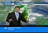
and now from washington's leading news station, this is news4 at 6:00. tonight sandy is beginning to make its presence felt in our area. wind and rain already picking up at the shore. conditions across the region will really begin to deteriorate over the next 12 hours. >> some parts of our area are already seeing flooding and to the east major roads are beginning to close. >> good evening. >> just minutes ago the federal government decided to close tomorrow. joining most school districts and county governments in our area. we have team coverage of the storm tonight across the metro area and along the shoreline, too. we begin with storm team 4 chief
6:01 pm
meteorologist doug kammerer with new information about sandy's track and the time line for potentially dangerous conditions here. doug? >> i think we're finally starting to understand just how big this storm is going to be and just how devastating it could potentially be. we've been talking about it for over a week now, making its way very close to our region. you can see where it is right now, and this is the interesting thing here. it is still moving out to sea, northeast right now at about 15 miles per hour, but you can see where the rain is lining up, and we are starting to see rain now across our region. we've also started to see -- rather tropical storm-force gusts of 30 to 40 miles an hour in parts of the area. again, tropical storm-force winds of 39 miles an hour or higher and we've seen those down toward the shore. now, current location, well down to the south and east of us, but what we're seeing is winds of 75 miles an hour close to the center here and the pressure now down to 952 millibars. that's a very strong storm. that is equivalent to a category 3 hurricane on most occasions, about you this storm will continue to make its way to the
6:02 pm
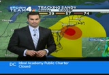
north and then back towards the west as we have been telling you. that's what we're worried about from this storm. take a look at this. this is a new graphic. the area in yellow is tropical storm-force winds sustained at 39 miles an hour. from boston to raleigh, that's what we're going to be in. sustained winds of near 40 miles an hour. gusts to 60 miles an hour. that's why this is such a big storm. there are numerous watches and warnings across our region. i'll try to break them all down for you coming up in about the next ten minutes. >> thank you, doug. as we said, the federal government and a lot of school districts have already canceled for tomorrow. some school districts have canceled classes for tuesday as well. we have a complete list at the bottom of the screen. all closings are also available on nbcwashington.com. there's already flooding, high winds, strong surf along the beaches from the carolinas to new jersey. >> most, if not all of those areas are now under mandatory evacuation notices. they're trying to get people out of danger before things get worse. >> wendy is in rehoboth beach
6:03 pm

now with look at conditions there. wendy? >> reporter: oh, it is rough here right now, jim. it's been rough starting around midday today. at this hour at 6:00, the governor has ordered all businesses in the coastal regions of rehoboth, dewey, and bethany to be closed at 6:00. at 8:00 is the deadline for everyone in three-quarters of a mile from the coast to get out of here. people are paying attention to this. as they saw as the sorm is getting closer, this is not something you want to play with. two young, buff, and experienced rehoboth lifeguards startled onlookers with this swim. >> if you don't know what you're doing, it's dangerous, but we've been swimmers for a long time. >> reporter: do your wives know you're out there? >> mine does not. i'm at the grocery store. >> reporter: the rest of the humans spent this stormy day watching the churning surf. >> it's going to be causing a lot of damage, but i don't feel that it's that dangerous. >> reporter: most people spent
6:04 pm

the day leaving. >> we were supposed to be staying here tonight but they told us they're evacuated. >> reporter: they're heading up to new york, not the best idea given the track of this storm. >> we're not calling the fighting irish for nothing. >> heading on the coastal road is no longer possible. the road block started in dewey. water has breached the road north of the indian river inlet bridge as this state trooper found out the hard way. this bustling beach town is now silent and shuttered. still oddly reassuring that rehoboth will roar again. bethany, by the way, if you are in bethany or you know someone in bethany, they're not trapped. there are other ways to get off bethany that require going inland and going around. it's a little bit of a longer detour but it is safe and they can get off. you just can't go on that coastal road anymore and that started this morning. reporting live from rehoboth, we will be here all evening, back at 11:00 tonight.
6:05 pm
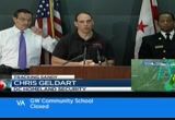
>> storm 4, wendy, thanks. states ever emergency in the district and all the states around us and with that police, government leaders, and utility companies have all hands on deck. >> derrick ward reports on that angle of the story. >> this storm is unique, large, dangerous, and unlike anything our region has experienced in a very long time. >> reporter: more sandbags were distributed to help keep those who will stay inside dry, but they should be wary of trees. >> you know there's one outside your apartment or your house or whatever, you need to make sure you're away from where that potential hazard is. >> reporter: with models showing expected hurricane-force winds lasting 24 hours and up to one it twons of rain per hour, the city is asking for federal disaster declaration ahead of the storm's landfall. >> to help defray the extra expenses. >> reporter: power outages are likely. they are calling in outside crews. >> we've received commitments from about 1473 crews at this
6:06 pm

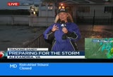
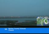
time. >> reporter: still, for them to be on the poles, that means darkened intersections to be treat as four-way stop signs until the public safety sector can get out and about. even they will be subject to high winds. >> when winds start to get around 50 miles an hour, issuing ohave officers to shelter in place on their beats. >> reporter: the feoremost piec of advice, don't go out if you don't have to. people in northern virginia are bracing for whatever sandy brings their way as well. >> many were out today making last-minute preparations for the storm. news 4's northern virginia bureau chief julie carey joining us from alexandria now. hi, julie. >> reporter: just now a fine mist calling here. look how murky it is out on the potomac. you can see the white caps whipped up, and that sailboat has been rocking and banging into that pier. alexandria, arlington, falls church, fairfax county, all declared a local state of emergency today to help them better deal with whatever sandy brings.
6:07 pm

this was the long line of cars that formed at an alexandria middle school parking lot. the hot commodity here, sandbags. >> an ata to gw. >> caller: truckload after truckload hauled into this location in old town were carted off as soon as they could be delivered. >> we got a basement that floods every now and then so i want to make sure we've got sandbags to go around the basement. >> reporter: in the hunting done area, they know all about flooded basements because theirs have filled in several past storms. regs dents were prepping their property. generators on stand by, trash cans, bungeed together, and check out this window treatment. >> flywood on there and waterproof tape to slow it down some so it won't gush in. >> reporter: there were also some cinder blocks handy to elevate the basement furniture. across northern virginia, residents and restaurants cleared their patios. the manager of this barbecue place delayed the week's food order in case the power goes. >> we're definitely worried about that. never fun to lose power.
6:08 pm
>> reporter: first responders were busy, too. virginia task force one was notified at one to pack up and be ready to deploy. >> we're activating 80 person from virginia task force one. >> reporter: in spite of the storm coming, at least somebody found a way to put sandy's leading edge of wind to good use. here is another view in old town, the water gushing onto the sidewalk here but this is only the beginning. to drive the point home about the seriousness of this storm, governor bob mcdonnell said on a conference call earlier this is the most unique powerful storm he's seen in his 20 years in public office. reporting live from alexandria, i'm julie carey, news4. >> we also have complete coverage of hurricane sandy on nbcwashington.com. there you can get the latest storm track and sign up to get our breaking news and weather alerts. we're also streaming all of our on air coverage online. all kinds of trouble with travel tonight ahead of this storm. we'll have a live report on the roads and the rails. >> public transportation shutting down in new york city
6:09 pm

and mandatory evacuations in place there. stay tuned for "nightly news" fo anncr: seven-hundred-thousand jobs. that's what the plan george allen supports... would cost our economy. newspapers called it "economically destructive." like allen's votes to give tax breaks to companies... that ship jobs overseas, his economic plan would... help big corporations, devastating the middle class. allen even voted against tax breaks for small businesses. virginia can't afford to go back to george allen. the democratic senatorial campaign committee... is responsible for the content of this advertising.
6:11 pm

we continue our coverage of the storm named sandy with the major impact it's having on travel. >> transportation reporter adam tus is in the news room to tell
6:12 pm

us what's going on in the sky, roads, and on the rails. >> jim, much like the weather situation, the travel situation going downhill fast and it's only going to get worse as we get into the heavy stuff tomorrow. here is what we know right now. amtrak, the main piece of information tonight, amtrak canceling all northeast corridor services tomorrow. in fact, amtrak says most service along the eastern seaboard will be shut down tomorrow. staying on the rails, marc service canceled tomorrow, vre service canceled tomorrow. as for metro, this just in, the transit agency says it will be making changes to service tomorrow. we don't know the exact changes, but it could mean something like a weekend schedule goes into effect tomorrow. on the roads at the bay bridge, a lot of people already trying to get off the eastern shore. that means backups approaching the bay bridge and, remember, when wind gusts are sustained around 55 miles an hour, the maryland transportation authority will typically shut down all lanes on the bay bridge. a lot of inner city bus companies shutting down service tomorrow. at the airports, here is a live look at reagan national.
6:13 pm
as you can imagine, a number of flight cancellations already in place, not just at reagan but also at dulles and dwi marshall. check ahead before heading out. at a certain point if you haven't already left the area and you have plans to, you're just going to have to settle in and ride this thing out. reporting live in the newsroom adam tus s, news4 4. >> pepco getting ready for this storm. we'll tell you what they're getting ready to avoid a repeat of what happened last summer. >> doug kammerer i

6:15 pm

ike leggett: gaming generated one hundred and eighty... million dollars for maryland schools. question seven will double it. rushern baker: question seven will add table games and... a new casino, generating millions of dollars... every year, without raising taxes. leggett: and audits will ensure the money goes...
6:16 pm

where it's supposed to. more jobs, and millions for schools. baker: question seven will be good for our kids... our teachers, and our schools. leggett: keep maryland money in maryland. baker: please vote for question seven. leggett: vote for question seven. pepco is not taking any chances with this storm. they're bringing in hundreds of extra employees for outages that are indeed expected. >> news4 chris gordon is live in gaithersburg tonight with mepco has set up a staging area. chris? >> reporter: it's on the montgomery county fair grounds which is close to 270 rockfield pike. they will be able to respond
6:17 pm

quickly when customers complain about power outages because of sandy. pepco is getting ready for whatever sandy has in store. additional repair crews have arrived from mississippi, tennessee, alabama, and texas with more coming tonight. shuttle buses transport the linemen from the staging area to hotels and back as 700 crew members are being fed meals at the mess hall set up here at the montgomery county fair grounds. >> right now these are crews coming in from out of state and there's a crew lead with them right now. what they're doing is they're probably having a safety message and then setting up the expectations for hotels and what's going on at the site here. >> reporter: back in july after the derecho, some pepco customers complained they went without power for five days or more. pepco feels it did a good job considering the extent of damage, and pepco knows that everyone will be watching how it handles sandy. is pepco aiming to do better this storm? >> we are doing the best we can,
6:18 pm

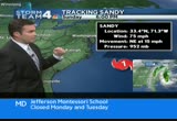
and, yes, we are aiming to do better. >> reporter: now, after sandy passes through, supervisors will go and assess damage throughout the area. however, these trucks cannot be deployed and put up their booms if high winds remain. so only after the high winds can they start to work on restoring power throughout the area. that's the latest live from the pepco staging area at the montgomery county fair grounds. chris gordon, news4, back to you. >> thank you, chris. this is a big storm and all of the area school systems, all the major school systems we have heard from are closing tomorrow as well as the federal government. >> that's very good news. i really think that's going to cut down on injuries. talking about the power. that's going to be the biggest thing is the power outages. they're not going to be able to get the power back on until the winds die down. we don't see that happening until during the day on wednesday most likely. so if your power goat out on monday, you're at least talking about one to two days without power. we want to make sure you're
6:19 pm
prepared for the storm. take a look right now. we'll show you what's happening outside. you can see the rain starting to fall across parts of the region. most of this is going to be on the lighter side and it's going to stay on the lighter side for the next couple hours before the storm starts to move in our direction. believe it or not, sandy is still moving out to sea right now and we're waiting for that turn to start. a lot of you at home going let's just hope it keeps going. that would be nice, wouldn't it? but it is going to make a turn. it's actually going to make a turn due to this area of low pressure out to the west. that's going to help bring sandy back up into our area. so, again, the official forecast from the national hurricane center has winds of 75 miles an hour currently. those are the current wind gusts right now. winds gusting upwards of 85 to 90 miles an hour and it's moving to the northeast at 15. it's expected to make a turn to the north and then back toward the northwest as we've been talking about for the last few days here. notice the cone of uncertainty. much, much narrower, much slimmer across the region and it encompasses parts of the delmarva including delaware and most of the state of new jersey. so this thing is going to hit between new york and rehoboth
6:20 pm

baeven, delawa beach shall delaware. you're like, that's a little to the north of us. it doesn't matter. we are all going to see tropical storm-force winds out thfer and that's why we're all under those high wind warnings. here is the current rain. you can see the rain invading the entire region right now, but the heavy he is rain has been out along the eastern shore and now down towards southern maryland. southern cape may county starting to get in on some of the heavier rain. upwards of 5 to 10 inches already along portions of the chesapeake and towards the eastern shore. this boundary has not been moving all that much and this may happen later during the day tomorrow and into tuesday as we get these boundaries setting up. here is where the storm is well out to the sea. you can see the rain associated with that. you can also see our cold front back toward the west that's trying but it's not able to get farther to the east so we're going to see these systems combine and that's why we're talking about such a massive system. so the impacts as we've talked about, low impacts today. we're seeing rain and winds upwards.
6:21 pm
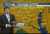
30 miles an hour. it's tomorrow we get into the high impact area with wind and rain, same deal goes for tuesday as the storm makes its way inland. strong winds, a lot of coastal flooding along the potomac, along the bay, and punl along the atlantic. heavy rain which will cause river flooding and power outages are will be the biggest concern with numerous trees down. the entire area under a high wind warnings for gusts upwards of 60 miles an hour. sustained winds between 30 and 40 miles an hour, so we're going to see a lot in the way of power outages. make sure you have your flashlights ready and make sure you have a plan together. here is the winds we're seeing out there right now. not too bad, 25 hours in washington, 31 in easton. we're seeing tropical storm-force winds in ocean city of 41 miles per hour. we did see a 50-mile-an-hour gust a little bit earlier. here is the gust that we're going to see, the potential wind. sunday, tonight, not too bad. upwards of 20 miles an hour. watch by tomorrow we start to get into the mid-30s over there towards the bay, but tomorrow afternoon into tomorrow evening,
6:22 pm

gusts to potentially 60 to maybe 70 miles per hour in some locations. this is going to be really tomorrow night i think the worst of this will be between noon tomorrow and midnight or rather noon tomorrow and 8:00 a.m. on tuesday morning. so we've got a long way to go here before the winds start to calm down. the other thing, the flooding. 5 to 10 inches of rain, we're going to see that likely in many parts of the area, so expect to see flooding and river flooding is going to be likely, and then tidal flooding along the potomac, along the chesapeake. 1 to 3 feet above high tide. we're talking about the potential for moderate flooding right now and it could become even worse. this is what you will see tomorrow. heavy rain. the winds will be increasing. we will see trees down. we will see power outages, and it's going to be rather cool. temperatures only in the low 50s with those winds gusting to 60. over the next couple days we continue the winds through the early morning hours on tuesday before things start to calm down. on wednesday a high of 54 with showers likely. that, of course, is halloween. thursday and friday a little bit better. right now the weekend coming out
6:23 pm

and the weekend looking pretty nice. we get to calm down a little bit. one thing i did not say right there, we could also see some snowflakes even in parts of our area and parts of west virginia and western maryland now under blizzard warnings. so this storm -- >> when would that happen? >> snow for us probably late tuesday. >> wow. >> just flakes. >> that's weird. >> keep us posted. we have sports coming up. a lot of ugliness in pittsburgh in three diffe teacher: this is west virginia, pennsylvania, delaware. and this is maryland. every year marylanders spend five hundred and fifty million gaming at casinos in these other states. question seven will build a new casino and bring table games to baltimore... generating hundreds of millions for schools. and that money has to go to education. it's the law. so vote for question seven. so we can stop spending all that money here, and keep maryland money in classrooms like mine. we were told to build a 30-foot stage.
6:24 pm

gathered the guys and we built that 30-foot stage, not knowing what it was for. just days later, all three shifts were told to assemble in the warehouse. a group of people walked out on that stage and told us that the plant is now closed and all of you are fired... i looked both ways, i looked at the crowd, and...we all just lost our jobs. we don't have an income. mitt romney made over 100 million dollars by shutting down our plant and devastated our lives. turns out that when we built that stage, it was like building my own coffin, and it just made me sick. [ male announcer ] priorities usa action is responsible for the content of this advertising.
6:25 pm

athat's what the plan georged allen supports...action would cost our economy. newspapers called it "economically destructive." like allen's votes to give tax breaks to companies... that ship jobs overseas, his economic plan would... help big corporations, devastating the middle class. allen even voted against tax breaks for small businesses. virginia can't afford to go back to george allen. the democratic senatorial campaign committee... is responsible for the content of this advertising.
6:26 pm

this is the xfinity sports desk brought to you by xfinity. >> i told you it was ugly, the weather was ugly, the pittsburgh uniforms were horrible. the defensive play was even worse. >> it was interesting, of course, and you want that time back, right? >> absolutely. >> cooley's back, london was playing, and the steelers brought out those ugly throwback jerseys, ugliest throwback
6:27 pm

jerseys ever. forget throwback, they should throw them away. redskins might want to trash the game film. it was a terrible, horrible, no good, very bad day. ten dropped passes and it ends with a little ugly just for jim. pick it up in the second quarter. steelers up 10-6, and they're going to go for more here on third and goal. shield your eyes. ben roethlisberger fakes, on the run he threads the needle to miller. it puts pittsburgh up 17-6. and now to that u-g-l-y, d'angelo hawk hall a little chippy and he loses it with the ref. we had to blur his mouth so you couldn't read what he was saying. he gets into it with the headline judge and d. hall is ejected. getting tough with the wrong uniform. the redskins lose 27-12. redskins fall to 3-5. the fifth time in the last ten seasons the skins have been 3-5 at the midway point. so they have been here before. dan hellie is in pittsburgh and
6:28 pm

he will have so much more tonight on red squins final, a whole half hour dedicated to today. >> do you know what that looked like today "the longest yard." isn't that the name of the movie? the prison team playing. >> exactly. >> with what's his name? >> i think that helped their game looking so ridiculous. >> you need a get out of jail free card. >> burt reynolds, he was in that movie.

181 Views
IN COLLECTIONS
WRC (NBC) Television Archive
  Television Archive News Search Service
Uploaded by TV Archive on
